
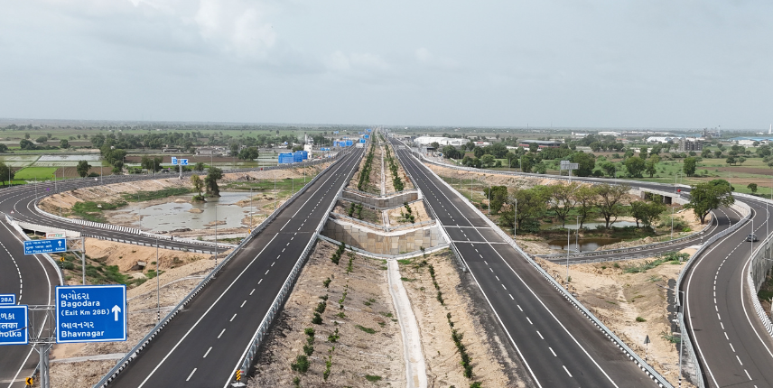
Before a city gets roads, industries, homes or commercial centres, it begins with a plan.
For Dholera SIR, that plan is especially important because the city is being developed as a greenfield economic and industrial ecosystem rather than as an extension of an already crowded urban centre.
The Dholera master plan acts as a long-term blueprint for:
- where industries can develop;
- where people may live;
- how commercial activity can grow;
- how infrastructure will operate;
- how different parts of the city will connect; and
- how development can expand over several phases.
The book Dholera: From Desert to Destiny describes the master plan not simply as a land-allocation document, but as a framework designed to guide the city’s development over decades. Dholera_Book_Final_Preview
Why Does a Master Plan Matter?
Many older cities grow organically.
A road comes first.
Then houses appear.
Industries expand.
Utilities are added later.
Commercial areas grow around population.
Over time, this can create pressure on transportation, drainage, electricity, land availability and public infrastructure.
Dholera is trying to follow the opposite approach:
Plan first. Build infrastructure. Then enable growth.
The objective is to ensure that the different components of the city work together rather than develop independently.
This is one of the central ideas behind Dholera’s planning model.
Planning for Future Demand, Not Just Today’s Demand
One of the more interesting elements of Dholera’s approach is its time horizon.
The planning is intended to consider not only present requirements but also the needs of:
- future populations;
- future industries;
- emerging technologies;
- larger transportation volumes;
- new infrastructure;
- changing business requirements; and
- long-term urban expansion.
The book describes this as planning beyond today’s requirements — creating a framework capable of supporting development across multiple generations.
That distinction is important.
Dholera is not being planned around what the region needs only today.
It is being planned around what a much larger economic ecosystem may require in the future.
Understanding Land Use in Dholera
A city cannot function efficiently if every activity develops randomly.
People need places to live.
Industries need appropriately planned land.
Businesses need commercial districts.
Communities need education, healthcare and recreation.
Transportation corridors need to connect all of them.
The Dholera master plan therefore organises development into different land-use categories.
Broadly, these include:
Industrial Development
Residential Development
Commercial Development
Public & Civic Infrastructure
Transportation & Utility Infrastructure
Green and Recreational Areas
The objective is to create a balanced city where economic activity and urban life develop together.
1. Industrial Zones: The Economic Engine
Industry lies at the centre of Dholera’s economic vision.
Significant portions of the planned city are intended to support industrial activity across sectors such as:
- manufacturing;
- engineering;
- electronics;
- semiconductor manufacturing;
- renewable energy;
- logistics; and
- technology-led industries.
The intention is not simply to create individual factories.
The larger idea is to build industrial ecosystems.
For example:
Large Manufacturer
↓
Component Suppliers
↓
Logistics & Warehousing
↓
Professional Services
↓
Employment
↓
Housing & Retail
↓
Additional Businesses
This ecosystem effect is what can potentially turn an industrial zone into a larger economic centre.
2. Residential Zones: Building Communities
A successful industrial city eventually needs people to live around the economic activity it creates.
This is why residential planning is an important part of the Dholera master plan.
Residential development is intended to support access to:
- housing;
- schools;
- healthcare;
- community facilities;
- recreation; and
- everyday services.
The broader idea is live + work + learn + access services within an integrated urban environment rather than treating housing as something separate from industrial development.
This integrated approach is one of the recurring principles in the book’s description of Dholera’s development. Dholera_Book_Final_Preview
3. Commercial Zones: Supporting the Economy
Industries and residents both create demand for commercial activity.
That can eventually include:
- offices;
- retail centres;
- hospitality;
- business services;
- banking and financial services;
- restaurants;
- entertainment;
- professional firms; and
- other service businesses.
Commercial areas therefore play an important role in creating a self-sustaining urban economy.
An industrial city cannot depend only on factories.
It needs the supporting businesses that allow industries, employees and residents to function efficiently.
4. Social & Civic Infrastructure
A modern city also needs infrastructure that does not directly generate industrial output but is essential to everyday life.
This includes facilities such as:
Education
Schools, colleges and future skill-development institutions.
Healthcare
Hospitals, clinics and supporting health infrastructure.
Government Services
Administrative and civic facilities.
Public Spaces
Parks, community areas and recreational facilities.
Sports & Culture
Infrastructure that contributes to quality of life.
The idea is important because attracting industries is only one part of developing Dholera.
Long-term success also depends upon attracting and retaining people.
The Activation Area: Where the Master Plan Becomes Visible
A city spread across hundreds of square kilometres cannot be developed at once.
Dholera therefore began with a priority development zone known as the Activation Area.
The Activation Area covers approximately 22.5 sq km within the larger Dholera region.
According to the book, it includes around:
| Infrastructure | Scale |
|---|---|
| Activation Area | ~22.5 sq km |
| Roads & associated utility networks | ~72 km |
| Water Treatment Plant | 50 MLD |
| Sewage Treatment Plant | 10 MLD |
| Common Effluent Treatment Plant | 20 MLD |
The book also notes that industrial land allotment had begun, with contiguous parcels ranging from roughly one acre to more than 330 acres at the time of writing.
The purpose of the Activation Area is essentially to demonstrate that the larger master plan can translate into functioning infrastructure on the ground.
It acts as Dholera’s proof of concept.
Why Is the Activation Area Important?
For a large greenfield project, plans alone are not enough.
Businesses want to know:
Is the road infrastructure actually there?
Can utilities support industrial operations?
Is water infrastructure available?
Can future expansion be supported?
Is development visible on the ground?
This is where the Activation Area becomes important.
It was designed to:
Demonstrate Readiness
Show visible infrastructure development.
Attract Industry
Create a functioning environment where industries can begin establishing operations.
Build Confidence
Allow businesses and stakeholders to evaluate physical progress.
Create Momentum
Use the first developed area as a catalyst for later phases.
In simple terms:
Master Plan → Activation Area → Infrastructure → Industry → Population → Wider Development
Roads Before Population
One of Dholera’s most interesting planning principles is the idea of building infrastructure ahead of large-scale demand.
In most existing cities, roads are repeatedly widened after populations increase.
Dholera’s planning model tries to anticipate future movement earlier.
The road network has therefore been planned together with:
- utility corridors;
- transportation requirements;
- industrial access;
- future expansion; and
- urban mobility.
This approach is designed to reduce the need for major retrofitting later.
What’s Beneath the Roads Matters Too
Some of the most important infrastructure in Dholera may be the infrastructure people rarely see.
Utility planning includes systems supporting:
- water supply;
- sewerage;
- stormwater management;
- power distribution;
- telecommunications; and
- future utility expansion.
Much of this infrastructure is planned underground.
That may sound like a small technical detail, but it matters greatly for a future city.
Older cities often face repeated road excavation because electricity, water, telecom and drainage infrastructure were installed separately at different times.
Integrated utility planning attempts to reduce that problem.
Smart Infrastructure from the Beginning
Dholera is also being positioned as a smart industrial city.
The term smart city can easily become marketing language, but at its simplest it means using data, connectivity and technology to operate urban systems more efficiently.
Dholera’s planning incorporates elements such as:
- high-speed communication networks;
- data connectivity;
- infrastructure monitoring;
- digital management systems;
- future technology readiness; and
- integrated city-management capabilities.
The objective is not simply to have technology inside the city.
It is to make technology part of how the city operates.
Integrated Command and Control
Modern planned cities increasingly use centralised platforms to monitor urban infrastructure.
Instead of transportation, utilities, public services and environmental monitoring functioning as completely separate systems, an integrated command-and-control approach allows city administrators to view multiple systems together.
This can potentially improve:
- infrastructure monitoring;
- emergency response;
- resource management;
- public services;
- transportation management; and
- operational decision-making.
In Dholera’s broader smart-city framework, digital infrastructure is therefore treated almost like the nervous system of the city.
Development Will Happen in Phases
One of the biggest mistakes people can make when studying a project of Dholera’s size is expecting the entire master plan to be developed simultaneously.
That is not how large cities are normally built.
Development is phased.
Infrastructure is introduced strategically.
Specific areas begin attracting economic activity.
Employment develops.
Residential and commercial demand follows.
Additional development areas then become more viable.
The book describes this as a structured growth process rather than an attempt to develop the entire region at once.
This distinction is particularly important for anyone evaluating land or property in the wider Dholera region.
Master Plan vs Ground Reality
For anyone studying Dholera, TNT Infra recommends separating three layers:
| Layer | What It Means |
|---|---|
| Master Plan | The long-term planned structure of the city |
| Under Development | Infrastructure/projects currently being executed |
| Operational/Completed | Infrastructure already available on ground |
A planned road is different from a road under construction.
A proposed commercial zone is different from an operational commercial district.
A future residential area is different from an already developed neighbourhood.
Understanding these distinctions helps buyers and businesses make more informed decisions.
What Should a Land Buyer Check on the Dholera Map?
Before considering any land opportunity around Dholera, don’t look only at the price.
Understand its relationship to the larger development plan.
Some important questions include:
- Which village is the land located in?
- Which Town Planning area does it fall under?
- What is the surrounding land use?
- How far is it from developed infrastructure?
- What connectivity exists today?
- What connectivity is planned?
- Is the land within or outside the SIR?
- What documentation is available?
- What development assumptions are being made?
- Which claims are current and which are future projections?
This is precisely where looking at the actual planning map becomes more useful than relying on a sales brochure.
Is Every Part of Dholera Developing at the Same Speed?
No.
And this is important.
The wider Dholera region is extremely large.
Different locations can have very different relationships to:
- the Activation Area;
- industrial developments;
- highways;
- the airport;
- trunk infrastructure;
- future TP development;
- villages; and
- other economic nodes.
Two plots described simply as being “in Dholera” can therefore represent very different propositions.
Location must be understood in context.
Why the Master Plan Matters for Investors
The master plan does not guarantee investment returns.
But it helps explain why one location may have a different development context from another.
Instead of asking only:
“What is the price per square yard?”
A more useful sequence is:
Where is the property?
↓
What surrounds it?
↓
What infrastructure exists?
↓
What is planned?
↓
At what stage is that infrastructure?
↓
What are the ownership and legal documents?
↓
What is the investment horizon?
Only then should price become part of the discussion.
The Bigger Dholera Story
Dholera’s master plan is ultimately about more than dividing land into coloured zones.
It represents an attempt to coordinate:
Land + Infrastructure + Industry + Technology + Housing + Services + Sustainability
into one long-term urban-development framework.
The ambition is significant.
But as the book repeatedly acknowledges, the real measure of Dholera’s success will be execution over time rather than the master plan alone.
Understand the Dholera Map with TNT Infra
At TNT Infra, we believe anyone considering Dholera should understand the location before discussing the investment.
Our team can help you understand:
Your Plot → Village → TP Area → Zone → Connectivity → Nearby Development → Documents → Long-Term Context