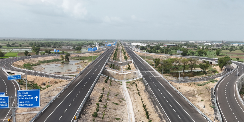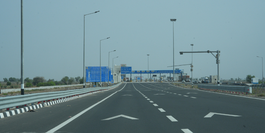

BDholera SIR is a development spread across a very large region.
But no city of that scale can be built all at once.
That is why the first major development zone is known as the Activation Area.
Think of it as the place where Dholera’s master plan starts becoming visible on the ground.
The book Dholera: From Desert to Destiny describes the Activation Area as the starting point of Dholera’s physical development — a priority zone where infrastructure could be built first, tested, demonstrated and used to support future expansion.
Its purpose was straightforward:
Build a functioning, investment-ready area first. Then expand development outward over time.
How Large Is the Dholera Activation Area?
The Activation Area covers approximately 22.5 sq km within the wider Dholera SIR.
According to the book, this first phase includes around 72 km of roads along with utility networks and major water and wastewater infrastructure.
| Infrastructure | Scale |
|---|---|
| Activation Area | Approx. 22.5 sq km |
| Roads with utility networks | Approx. 72 km |
| Water Treatment Plant | 50 MLD |
| Sewage Treatment Plant | 10 MLD |
| Common Effluent Treatment Plant | 20 MLD |
These figures are part of the book’s September 2026 Dholera fact summary. Dholera_Book_Final_Preview
Why Was the Activation Area Created?
Large infrastructure projects face a common challenge:
People can see plans.
They can see presentations.
They can see master-plan drawings.
But businesses and investors ultimately want to see execution.
The Activation Area was designed to demonstrate that execution.
It serves four important purposes:
Demonstrate Readiness
Show that physical development is actually taking place.
Support Industry
Create infrastructure capable of supporting future business activity.
Build Confidence
Give stakeholders something tangible to evaluate.
Create Momentum
Use the first developed zone to support subsequent phases.
In that sense, the Activation Area acts as a proof of concept for Dholera.
From Planning to Physical Infrastructure
For years, much of the discussion around Dholera centred on:
- policy;
- planning;
- industrial corridors;
- master plans;
- future industries; and
- long-term development.
The Activation Area represents a transition from planning to physical execution.
Roads appeared.
Utility networks were introduced.
Technology infrastructure started being integrated.
Water and wastewater systems became part of the development framework.
That transition matters because infrastructure can be measured and inspected in a way that future projections cannot.
Roads Before Population
One of the defining principles of the Activation Area is:
Infrastructure Before Demand
In many older cities, roads expand only after population and traffic increase.
Dholera follows a different model.
Road infrastructure is being established ahead of large-scale urbanisation.
The book describes this planning approach as involving:
- wide roads;
- future-ready corridors;
- integrated transport planning; and
- connectivity designed for future growth.
The objective is to reduce the need to continuously retrofit the city as economic activity increases.
Why Roads Matter to an Industrial City
Roads are not simply about convenience.
For industries, road infrastructure directly affects:
- logistics;
- employee mobility;
- movement of raw materials;
- movement of finished goods;
- access to suppliers;
- emergency response;
- expansion potential; and
- operational efficiency.
This is why transportation infrastructure is such an important part of Dholera’s economic development strategy.
A company evaluating a location is much more likely to take that location seriously when basic transportation infrastructure already exists.
The Infrastructure You Cannot See
One of the most important aspects of Dholera’s Activation Area is beneath the surface.
The utility infrastructure is intended to support systems such as:
- water supply;
- sewerage;
- stormwater management;
- power distribution;
- telecommunications; and
- future utility expansion.
Much of this infrastructure is planned underground.
That is significant because many older cities developed utilities separately over decades.
A water line was installed.
Then a telecom cable.
Later, electricity infrastructure.
Then drainage.
Roads had to be repeatedly excavated.
Dholera’s approach is intended to integrate these systems much earlier in the city’s development.
Common Utility Planning
Integrated utility planning can potentially make a city easier to manage over time.
Instead of treating each service independently, multiple utilities can be organised through planned corridors.
This approach can help with:
Maintenance
Infrastructure can be accessed more efficiently.
Road Protection
Repeated digging of roads may be reduced.
Coordination
Different services can be managed together.
Future Expansion
Additional infrastructure can be accommodated as the city grows.
The book describes this type of “invisible infrastructure” as one of the most important foundations of a functioning future city.
Water Infrastructure in the Activation Area
A large industrial city cannot function without reliable water systems.
The Activation Area’s first-phase infrastructure described in the book includes:
50 MLD Water Treatment Plant
Designed to support future water requirements.
10 MLD Sewage Treatment Plant
Important for sanitation and wastewater management.
20 MLD Common Effluent Treatment Plant
Relevant to the treatment of industrial effluent.
Dholera_Book_Final_Preview
These facilities matter because industrial development depends not just on land and roads but also on reliable supporting utilities.
Stormwater Management
Water planning also involves managing rainfall and drainage.
As cities expand, large paved areas can increase runoff.
Without proper stormwater infrastructure, urban areas can face:
- waterlogging;
- flooding;
- infrastructure damage; and
- operational disruption.
Dholera’s planning framework includes stormwater management as part of its wider infrastructure strategy.
Again, this reflects the same principle:
plan before the problem appears.
Smart Infrastructure from Day One
The Activation Area is not intended to function like a conventional industrial estate.
Technology forms part of the planning framework.
The book discusses systems such as:
- sensors;
- digital monitoring;
- communication networks;
- automation;
- data connectivity; and
- smart infrastructure management.
Rather than adding these systems after the city becomes populated, the concept is to make digital infrastructure part of the foundation itself.
Digital Infrastructure: The City’s Nervous System
Modern cities depend on more than physical roads.
They also depend on information.
Factories need connectivity.
Government systems need data.
Utilities need monitoring.
Citizens increasingly expect digital services.
The book compares digital infrastructure to the nervous system of a city.
Just as roads move people and goods, digital networks move information.
This infrastructure can support:
- real-time monitoring;
- faster decision-making;
- utility management;
- public-service delivery;
- emergency response; and
- future technologies.
Industrial Land in the Activation Area
According to the book, industrial land allotment had already begun within the Activation Area by the time of writing.
It notes contiguous industrial parcels ranging from approximately one acre to more than 330 acres.
That scale is important.
Large manufacturing facilities often require substantial contiguous land along with:
- utilities;
- road access;
- infrastructure capacity;
- logistics connectivity; and
- scope for expansion.
The Activation Area is intended to create precisely this kind of environment.
Why the Activation Area Matters to Investors
For an investor, the Activation Area is important not simply because of its physical size.
It represents evidence of execution.
An investor evaluating a developing region may ask:
Is infrastructure actually available?
Are roads visible?
Are utility systems being developed?
Can industries operate here?
Is the project moving beyond drawings?
The Activation Area was specifically intended to help answer such questions.
This is why the book characterises it as a:
- demonstration zone;
- development catalyst;
- confidence-building mechanism; and
- platform for future expansion.
Why the Activation Area Matters Beyond Its Boundaries
The importance of the Activation Area is not limited to the 22.5 sq km it occupies.
Its larger role is to help create momentum for development around it.
The underlying logic is:
Activation Area Develops
↓
Infrastructure Becomes Operational
↓
Industries Enter
↓
Jobs & Business Activity Grow
↓
Supporting Services Develop
↓
Adjacent Development Becomes More Viable
↓
Dholera Expands in Phases
The book describes the Activation Area as a potential springboard for the phased development of adjoining Town Planning areas.
Is the Entire Dholera SIR an Activation Area?
No.
This distinction is extremely important.
Dholera SIR is much larger than the Activation Area.
The Activation Area represents the first priority development zone, not the entire project.
So when somebody says:
“This property is in Dholera.”
that alone does not explain its relationship to the current phase of development.
A better question is:
“Where exactly is it in relation to the Activation Area and other infrastructure?”
Questions to Ask Before Buying Land Near Dholera
If you are considering property in the wider Dholera region, the Activation Area should form part of your location analysis.
Ask:
- How far is the property from the Activation Area?
- Which village does it fall in?
- Which planning area is it associated with?
- What is the surrounding land use?
- Which roads currently provide access?
- What infrastructure already exists nearby?
- What infrastructure is still planned?
- Is the property inside or outside Dholera SIR?
- What documentation supports the property’s title?
- Is the quoted future development part of an official plan or only a marketing claim?
These questions are usually more useful than simply asking whether the land is “near Dholera.”
Activation Area vs Entire Dholera SIR
| Activation Area | Wider Dholera SIR |
|---|---|
| Approx. 22.5 sq km | Approx. 920 sq km total region |
| Priority first phase | Long-term development region |
| Major trunk infrastructure | Development progresses in phases |
| Physical infrastructure visible | Different areas at different stages |
| Demonstration of master plan | Full long-term city vision |
This difference should be understood before analysing any land opportunity.
What Does the Activation Area Tell Us About Dholera?
Perhaps the most valuable thing about the Activation Area is that it gives people a way to distinguish between vision and execution.
The master plan tells us what Dholera intends to become.
The Activation Area helps show how that plan begins translating into physical infrastructure.
In the language of the book:
Roads replace drawings.
Infrastructure replaces projections.
Development replaces speculation.
That is why this first phase occupies such an important place in Dholera’s development story.
Understand Dholera Before You Invest
At TNT Infra, we believe Dholera should be understood location by location rather than sold through broad claims.
Before considering land, our team can help you understand: